
Dolly Sods Wilderness, WV Backpacking – June 2012
Dolly Sods Wilderness Backpacking Overview
Complete Dolly Sods Photo Gallery | Dolly Sods Wilderness Video
- Location – Dolly Sods Wilderness, West Virginia
- Park – Monongahela National Forest
- Trail Hiked – Custom Route
- Miles Driven To Destination – 920 miles roundtrip
- Length Of Time Hiked – 4 days, 3 nights
- Trail Type – Loop
- Miles Hiked – 21.9
- Trail Difficulty – 4.5/10
- Fires Allowed – Yes
Get a printed topographical map of the above GPX route here: Dolly Sods Wilderness Topo Map
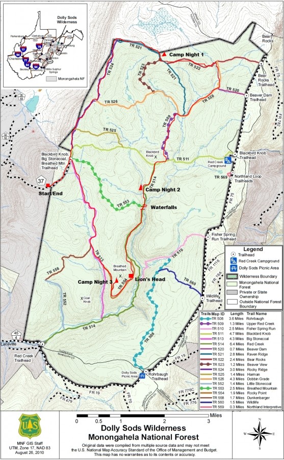
Download this map without my writing on it here: http://www.fs.usda.gov/Internet/FSE_DOCUMENTS/stelprdb5152038.pdf
Only three weeks after returning from the Gila Wilderness, NM I decided that I wanted to take my father somewhere for his birthday instead of getting him another crappy gift that we’ll both have forgotten about by the next year. He’d never been on a hike over 4 miles and that was without a pack, so for a guy turning 61 this was going to be an adventure. I picked the Dolly Sods Wilderness because it looked like it had a lot to offer in a small area, and was not going to be too physically demanding for dad. Also, it was “only” an 8.5 hour drive from home.
Getting There
We got up at 5am and cooked breakfast, and headed out the door by 6am. We were able to beat the morning rush hour traffic and get past the worst of it without delays. Ohio’s toll road got us for $10.50, and the PA toll road totaled nearly $10 as well. Nothing like paying to drive on roads that are always under construction! Glad we don’t have toll roads in my home state. Ohio is a pretty boring drive, but once we got into Pennsylvania the landscape was much more to look at. Maryland and West Virginia were both beautiful drives, the kind you don’t mind driving through at all.
We got to our planned trailhead at around 3:30pm. We parked at the Blackbird Knob/Big Stonecoal/Breathed Mountain trailhead off Public Road 80 (aka Freeland Rd or hwy 37). We expected to have been able to drive all the way up to the trailhead itself, but deep puddles and rough road ahead were signs that my small car wasn’t to go any farther. We ended up having to hike an extra mile to the trailhead itself from where we parked our car. Even if you have a truck, you could have only gone a few hundred yards farther before large rocks block the path from here from any vehicle traffic. So, add an extra mile if you plan to start here.
Day 1 – June 4th, 2012

Cairn On The Rocky Ridge Trail
From the moment we got out of the car, we noticed how the climate was different here. It was fairly cool out, maybe in the upper 50’s and windy. Once you finally reach the actual trailhead itself, you’ll see signs for several trails that branch off from this area. We hiked north on the Rocky Ridge Trail, number 524. This was a really nice hike, and great way to start our trip. There are excellent views to the West, but since this trail is right on the Wilderness boundary at this point, you can still see many signs of civilization down below… houses, roads, farms, etc. We pretty much followed the perimeter of the park’s Northwestern corner on our first day, constantly hugging the boundary line. This area was covered with large boulders and rocky outcrops that I would have loved to climb, but we didn’t have a lot of time to spare. Today, we were trying to make it to the junction of the Raven Ridge Trail and Beaver View Trail, trail numbers 521 and 524.

Hiking The Rocky Ridge Trail

Dad on the Rocky Ridge Trail

Northern section of the Rocky Ridge Trail
We made it to our planned destination around 6:30, which ended up being a little over 6 miles. Not bad for 3 hours, with a 61 year old first timer! Camp was a small clearing under some pine trees along the Raven Ridge Trail. I helped my dad set up his tent (my spare one-man, an Alps Mountaineering Zephyr 1) since it was his first time using it. The weather was looking cloudy, so we put our packs in the vestibules and headed down the trail to find a place to cook our dinner. Usually on my first or even second night in the backcountry, I’ll eat a nice meal like burgers or italian sausages. If you freeze them and keep them in a cooler until you reach the trail, these types of foods can be kept 1-2 days depending on the temperature and how well you keep them insulated in your backpack. I know many people don’t do this, but I like to eat GOOD! Unfortunately, I forgot the cheese for our burgers. But that’s the only thing I forgot for this entire trip, and seeing how as I planned it in such little time, I’m ok with that.
It was nearly 9pm by the time we finished cooking and cleaning, and by this time my old man was worn out. He was off to bed, and I did the same about 30 minutes later. This night was eerily quiet… I don’t ever remember having such a quiet night in the woods. When I was trying to get to sleep, I couldn’t hear one cricket, bird, anything. It was so quiet, all I could hear is a slight ringing/buzzing in my ears.
Day 2 – June 5th, 2012
My alarm went off at 7am and it was time to get out of bed. My dad is an early bird, and was already up on his own without an type of alarm. It was pretty overcast, and looked like rain in the distance. It looked like this the whole afternoon/evening the day before though and we didn’t see rain then, so we hoped today would be the same. We hit the trail around 8:30am and headed East on the Bear Rocks Trail, number 522. This area had nice views of rolling hills and meadows, with low rain clouds at the tree tops in the distance. The openness of this terrain was a welcome sight to my last hike in New Mexico.

Raven Ridge Trail just south of the Bear Rocks Trail
Upper Red Creek along the Dobbins Grade Trail
Shortly after turning hitting the Dobbins Grade Trail, number 526, we crossed our first stream, the upper portion of the Red Creek. After hiking a bit farther, we passed the river again, which was deeper and wider at this point. We decided to drop our packs and try fishing some of the small pools. I usually bring a collapsible rod strapped to the outside of my pack and store my reel inside. My dad brought his fly rod, in a case strapped to the side of his backpack. A few minutes after throwing our lines in the water, an older man walked by on the trail above us, and asked if we caught anything. This was the first person we’d seen, but not the last. After a half hour, we weren’t getting any action and we called it quits.

Red Creek along the Dobbins Grade, near Raven’s Ridge Trail intersection
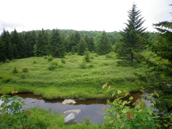
Eventually this area became very wet and boggy as we made our way down the Dobbins Grade Trail. This was probably my least favorite section of our hike. Everywhere you stepped was wet and muddy, sometimes mid shin depth and probably much deeper in areas we avoided. If I were to hike this area again, I’d follow a ridge on higher ground rather than trekking through this swampy area. I can’t complain though, because my boots did keep my feet dry. My dad’s brand new thinsulate water proof boots did not keep his feet dry, but once again my Zamberlains served me well. Before I left for this hike I applied some Sno-Seal on them to treat the leather and water proof them. At first, the water was beading off pretty well, but eventually the wax wore off and although the water didn’t bead up, they still didn’t leak.
Once we hit the Upper Red Creek Trail, number 509, we followed it South and left the sinking mud pits of the Dobbins behind. This trail was much drier and pleasant. After 1.25 miles, the 509 ends at the Blackbird Knob trail, number 511. We followed this west for 1/3 mile and continued south on the Red Creek Trail, # 514. Our plan for today was to stop at a campsite along this trail, explore the river and it’s waterfalls and maybe get some fishing in. We found a great campsite along the river by 12:30pm, probably the earliest I’ve ever stopped hiking. We’d covered 6 miles already so this was good enough for me. I had to keep in mind that my dad is not used to this kind of activity, and I tried to keep the hike as easy as possible for him. His only complaint so far was that my crappy High Sierra backpacking was hurting his hip. If anything, I was expecting a back problem… if you could see how this backpack sits on your back, you’d understand. The straps at the top have a buckle that prevents the weight from being pulled right up to your back, leaving a gap between your back and the backpack. I put the pack on and could feel the weight of it just wanting to pull you backwards.

They don’t call it Red Creek for nothing
It still looked like it was going to rain, so we promptly set up camp. We then headed up the river a few hundred feet to check out a small waterfall. After snapping some pictures here, we headed downstream through the river, hoping rocks and following the banks past our campsite. There were several other groups of people camping just a few hundred yards downstream from us near another small waterfall, at the forks of the Red Creek and another stream. We hiked upstream of one of the forks for a ways, but didn’t see any waterfalls here.

Waterfall on the Red Creek with a cave behind it

Adjusting the shutter speed to blur the water. Still practicing!

View of the waterfall from higher ground
We headed back to the forks and downstream along the other direction. It was starting to sprinkle now, but we kept going as there we encountered numerous waterfalls that became more impressive as you progressed downriver. With the added beauty came increasingly difficult terrain. We came up to a waterfall that was 15 feet or so in height that had a good sized cave behind the falls just as it began to rain harder. The cave provided excellent shelter from the rain, but after 2 hours it was still coming down. I suggested that we make a fire to warm up a bit and to give us something to do. Even though there were plenty of sticks in this cave, they were pretty damp and we had no dry tinder. We spent a good 20 minutes trying to get this fire lit but it did not want to catch. I flipped over a large rock and there was a small, wet piece of birch bark underneath. This was all we needed to get it going, and soon we had a roaring fire. But wouldn’t you know it… the rain stopped 10 minutes later!
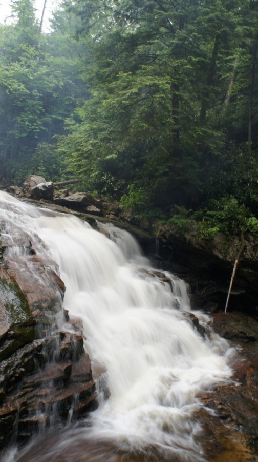
Waterfall on Red Creek

Dad tending to the fire
Taking advantage of the break in the weather, we headed back to camp. We had planned on cooking hot dogs over the fire tonight, but the weather didn’t look like it was going to cooperate for long. All the firewood we gathered earlier was already soaked. Fortunately, there were a lot of birch trees in the area and with a few handfuls of bark, we just might be able to have a fire after all. We gathered more “dry” firewood and tinder from areas underneath pine trees and rock overhangs, and started a fire with the birch bark once again. Once lit, even the wet stuff was burning. However, the fire was requiring a lot of attention and we didn’t have many large pieces of wood, so we ate our night 3 dinner tonight, 2 tortillas each with cheese and pepperoni. Hopefully tomorrow night will be dry so we can cook the dogs over a fire.
I went to bed around 10pm tonight, and it wasn’t raining at the moment. Minutes after I laid down, I heard a small animal moving around very close to my tent. VERY close. I shouted at it but whatever it was would not go away. I got up and out of the tent to make my presence known, but didn’t see anything. I laid down again and didn’t hear anything else, and eventually fell asleep.
Day 3 – June 6th, 2012
I woke up around 4am to the sound of rain. It wasn’t heavy, but it the fact that it was raining at all was disheartening. Today we were supposed to hike to Breathed Mountain and visit the Lion’s Head. I went back to sleep and woke up at 7 when my alarm went off. It was still raining, and my dad was up walking around with his rain gear on. I opted to stay in my tent, and figured we’d wait a few hours to see if the weather clears up before breaking camp. We only had to hike about 4 miles today, so there was no hurry.
Eventually, the rain let up after 11am and I crawled out of my tent. When I reached into my backpack to grab breakfast, which was in my vestibule, I saw evidence of the animal that had been rooting around near my tent. I had a ziplock bag with hot dog buns and bagels that was chewed open and had mouse crap all around it. I usually don’t hang my food, because I use these OP Saks, which are advertised to block the scent of anything inside. I’ve tested these bags by putting food inside it and putting it under my dog’s nose, and the dog had no interest in it. However, my bread was in a separate ziplock bag that was not stored inside the OP Sak, and it fell victim to the mouse. Fortunately only 1 bagel and a few hot dog buns were affected, and it wasn’t a total loss. Lesson learned.
The weather appeared to be clearing up at this point so we decided to pack up and head out. And by clearing up, I mean becoming only 95% cloudy. Seeing a little patch of blue in the sky was a glimmer of hope as broke camp around 12:30 and headed South on the Red Creek Trail. I was disappointed that this trail had no view of the river below, as this is where I saw some nice waterfalls the day earlier. Not having the chance to push farther downstream yesterday and now not having a view from the trail was killing me! You could rear the roar of the water for a ways, before the trail curved away from the river. The trail was muddy, but still not as bad as the Dobbins Grade Trail.

Hiking the Rocky Point Trail
Between the Breathed Mountain Trail, 553, and the Rocky Point Trail, 554 was a relatively easy hike. There really wasn’t much to see here though, so we made good time through this section and took the Rocky Point Trail. I had read there was a campsite near Lion’s Head, a rock formation on Breathed Mountain, so my plan was to camp up there for our last night. I had considered camping here the first night and doing the loop in the opposite direction, but am now glad that I chose to do it this way. The weather was looking better and just maybe we’d get a chance to take some pictures of the sunset and sunrise here without cloud cover. We found the side trail near the Southern end of the Rocky Point Trail, on the West side. After a short scramble up some rocks, we found a small campsite right on the edge of a wooded area. It was barely large enough for our two one-man tents, but we made it work. My tent was sopping wet when I set it up and after it had rained several more times that afternoon, I noticed it was now completely dry thanks to the pine tree above. Usually when it rains at camp, I’ll just hang out in my tent. My area was dry enough to just stand out in the rain, which was really nice.

Campsite near the Lion’s Head

View from our campsite on Breathed Mountain

Me on the rocks of Breathed Mountain
We spent the afternoon exploring the open rocky area surrounding the Lion’s Head and snapping pictures. That is, of course, in between the frequent rain showers. Navigating these rocks required jumping over deep cracks ind gullies form time to time, but nothing too extreme. The rocks were not slippery, even when wet. In fact, they had a sandpaper-like grip which was nice for once. There were tons of pinkish flowers up here which I was not expecting to see on an exposed rock face, but added to the beauty of this already amazing vista. I had an elevated view of my surroundings in a 270 degree field of view, and could hear the distant roar of Red Creek below. No wonder this is known as the best view in the Dolly Sods Wilderness!
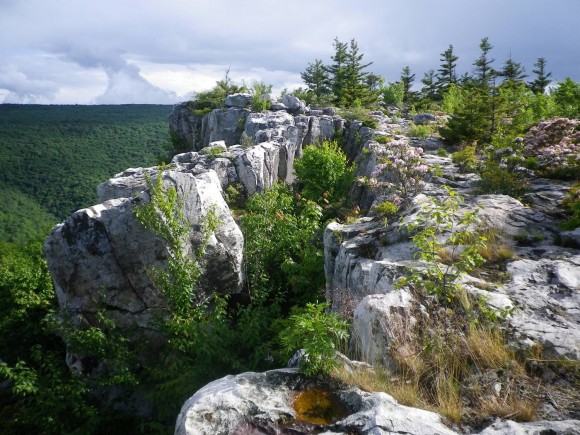
Breathed Mountain View
Breathed Mountain View

The infamous Lion’s head

The last of the nasty weather rolling through
There were two other guys up here who we ended up talking to for a while. They were locals, both in their early 20’s. One of them had never been to the Dolly Sods Wilderness or backpacking at all for that matter, but I if I remember right they both frequent Seneca Rocks nearby for rock climbing. They were taking pictures on the Lion’s Head and wanted to “trade” pictures with us. My dad and I stepped out onto the Lion’s Head as they took a few pictures of us together, and then we returned the favor. They were busy climbing so I set their camera on one of their backpacks and I noticed one of them had the same backpack as the one my dad was using, the High Sierra 75. Do yourself a favor and spend a little more money on a better pack if you plan to use it more than once…this thing sucks. Check my gear section for the complete review.

We had an awesome view of the sunset as the weather cleared
Again, finding dry firewood would be a challenge. We gathered even less than the night before but enough to cook with. My dad gathered some birch bark earlier and had it stuffed in his pocket. This got the fire going rather quickly and it was time to grill some hot dogs! Since that damn mouse ate some of the buns, I had to “double up” the meat in each bun. This was another meal where I wish I remembered to bring the cheese… I always put shredded cheddar on mine, it’s great! But to anyone in the backcountry, a couple of plain hot dogs is as good as it gets. They must have smelled great, because I saw another mouse on the rocks below while we were eating. I grabbed a 20lb rock and hurled it at the mouse, and I still don’t know how he didn’t get crushed… it looked like it landed right on top of him! It scurried away and we did not see any more animals in the area or hear any throughout the night.
Day 4 – May 7th, 2012

Setting up the tripod shortly after 5am
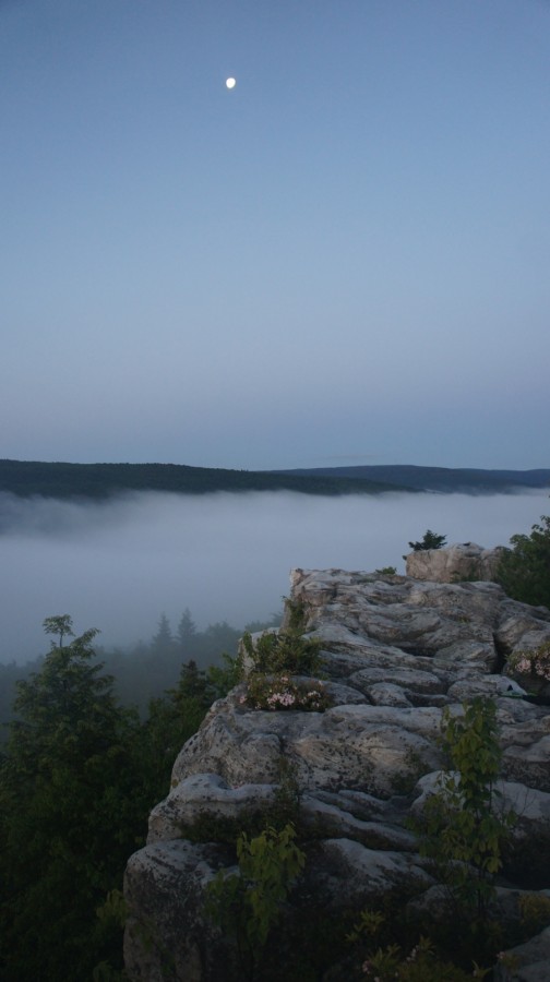
Moon and the mist

Sunrise in the Dolly Sods Wilderness
I woke up at 5am today to watch and photograph the sunrise, and I’m glad I did because the weather had cleared overnight and the sky was as clear as you could get. Immediately after leaving the cover of the trees near camp and making my way onto the exposed rocks, I could see the intensely thick cloud cover in the valleys. I’ve never seen anything like this before… it was awe-inspiring. While waiting for the sun to come up, I set up my tripod and fooled around with my new camera, a Sony Nex-5. I have to admit though, I’m a complete novice when it comes to photography. I really need to educate myself more but haven’t had the time before this trip. Regardless, I was going to fool around with it and see what I could do. This really just consisted of adjusting the aperture and shutter speed manually. I had a polarized filter which I used for most of the trip as well.

Wow!!


The sun rose around 6am, and the rapid changes in lighting offered many photo opportunities. The fog had an orange glow to it as the sun climbed higher in the sky. The moon was still very brightly visible as well… a stark contrast to the vividly blue sky. Shortly after sun rise, my dad got up and joined me. He took a few pictures with his camera, but I easily snapped over a hundred this morning.


We headed back to camp around 7:30am to pack up and head back to the car. Today’s hike would be around 5 miles. We were almost out of water and began to ration it to last us to the car. I had eaten a Met-rx bar earlier, around 7am, but this is not enough for me. I was pretty hungry by the time we hit the trail at 8:30, but I didn’t want to eat without having enough water to drink, so I skipped a full breakfast this morning.
Back on the Rocky Point Trail, it became less rocky as we headed North. After reaching Big Stonecoal Trail, number 513, it’s a straight shot back to the trailhead we started at. From this point, it’s about 3 miles to the trailhead, and another mile to the car from there. Now on the 513, the two hikers we saw up by the Lion’s Head the night before passes us. For the rest of the morning, we’d play leap frog on the trail, passing each other several times. Not long after, we passed a cascading waterfall about 20 feet in height. I climbed down to get some pictures, and then it’s back to the trail.

Another waterfall on the Red Creek
The next section of the trial consisted of multiple meadows separated by patchy wooded areas. It was pretty wet through here, but there was almost always a rock or log to hop your way past anything that looked deep. There were a few campsites through here that would have been nice, but we didn’t bother to investigate. We were both ready to get back to the car, and didn’t stop for much. After passing through a pine forest, the trail became rocky again and was wreaking havoc on Dad’s endurance. He doesn’t complain though, and before you know it we were back at the trailhead. Only 1 mile left to go! This section seemed twice as long coming back. When we got within sight of the car, there were three people on horseback coming our way. One of the horses got spooked by the sound of our trekking poles hitting the rocky ground and looked like he was going to bite us!
Final Thoughts
The Dolly Sods Wilderness has it’s own little climate pattern. It’s a wet region, bring good water proof boots and your rain gear. Also, a tarp would have been nice so that we had something to sit under when it rains. I’ve carried one before but have opted not to recently due to weight and bulkiness… I’d have carried it this time but the weather forecast looked good before we left so I chose not to. Be prepared to start a fire in wet conditions, or have no fire at all. If you choose to hike that route we took, leave your fishing pole at home. We didn’t see any fish anywhere, and had no luck fishing.
This hike wasn’t particularly difficult, and is suitable for most people. There were some ups and downs, but never anything real steep and nor was it for longer than a tenth of a mile or so.
I’m really glad I did this hike. Dad had a good time, and I know this trip will be something he’ll never forget. Watching the sunrise on Breathed Mountain was incredible, and worth the drive alone. I highly recommend camping up by the Lion’s Head and spending some time up here.
Complete Dolly Sods Photo Gallery
As always, questions and comments are welcome!
If you found my trip report useful, please don’t hesitate to leave a comment! Alternatively, if you feel you have any information you’d like to share with others regarding this hike, please feel free to leave that below in a comment as well.
[tcb_comment_count]


